December 2025
54°18'16.0"N 2°11'35.4"W
This month’s Polaris Bikewear route is a simple but stunning 32km gravel / easy XC loop heading out from the gorgeous village of Hawes in Wensleydale, North Yorkshire. And yes, that does mean a lot of cheese related highlights. But also, a Roman road and fort, timeless dry stone wall pastures, raw rocky upland landscapes, a peat bog you can see from space, and stunning panoramic views across several Dales.
It’s super easy in terms of navigation and ‘trucker cap’ topography means a nice flat warm up, one big climb, a wildly remote loop at the top and then a big descent home again. There’s a simple ‘bonus loop’ add on into Langstrothdale which we’ll add to the end of the route description too. Even our short route has significant weather exposure for at least half of the loop, no refuelling options once you’re a quarter of the way round, and zero shelter on the tops apart from some dry stone walls. That means you need to pack / plan for a fully self-supported wilderness ride and be aware that things can get very nasty, very fast up on Fleet Moss. On the plus side the 9km mostly off-road climb of High Cam Road isn’t as horrible as it sounds, as long as you don’t go silly at the start.
POLARIS Hawes Roman Rough Stuff
31.9KM, 625M VERTICAL
Start and finish point - The route starts and finishes in Hawes, a deservedly popular tourist hub nestling at a pinch point in the stunning valley of Wensleydale. As well as being a fantastic centre for riding and hiking, there’s also a couple of museums, a restored mill, a ropemakers, and the famous Wensleydale Creamery which gets 250,000 visitors a year sampling it’s delicate dairy delights.
Hawes also has a range of shops, including a pharmacy and a petrol station, and plenty of places to stay, from camping and Youth Hostel to fancy boutique hotels.
Getting there - I’ve done it again this time but it has struck me that this is pretty pointless as I’m pretty sure everyone will just stick Hawes in a GPS and follow that.
Hawes is right in the centre of the Dales which makes it quite awkward to reach from anywhere so prepare to be patient.
From the north west come down the M6 onto the A684 through Sedbergh.
From the south west come up the M6 onto the A59, then A685 and A65 to Settle before heading up through Ribblesdale.
From the south head up to Leeds then the A65 to Skipton and the B6265 past Grassington up Wharfedale to Wensleydale.
From the north east come down the A1 to Scotch Corner, then through Richmond, over to Leyburn and then west up Wensleydale.
what3words ///bonnet.buyers.reactions
This what3words address refers to a 3 metre square location. Tap the link or enter the 3 words into the free what3words app to find it.
For full navigation data download the GPX file and watch the Strava fly through. Then watch our ride video for a highlights preview of the route.
Stops & shops
Hawes has a wide range of places to eat and drink including the excellent cafe at Stage 1 Cycles where we got a pre ride brew and cake, and then excellent burgers, sandwiches and soup afterwards.
There are pubs and a shop in Bainbridge after 8km too, but after that you’re on your own for the rest of the route so pack accordingly.
Route information
Hawes to Bainbridge 0 - 8km
Starting from the car park of the Dales Countryside Museum puts you in the perfect spot to learn some local history and grab some spares / snacks and a starting brew at Stage 1 cycles. It also lets you dodge the one-way system in Hawes and head northwards over the old railway and the river Ure on the old multi arch Haylands bridge. It’s aptly named too, as it spans between broad meadows that are in stark contrast to the steeply rising hills to north and south. This bottleneck in turn is why the Norse settlers who thrived in this remote Scandinavian style landscape gave Hawes (‘Pass’ in old Norse) its name.
It was over a thousand years later that it became a settlement of any size though, growing as wool and flax trades flourished, and local lead mining became more important in the 17th century. It wasn’t until the very end of the 18th century that the turnpike road between Richmond and Lancaster was finally diverted from the course of the Roman Road and through the town, with the railway arriving 70 years after that.
This relatively late start explains the timeless landscape that you turn eastwards into (1.5km) once you’ve opened your legs on a short climb up towards Sedbusk. From here the road weaves and rolls gradually downwards through ancient dry stone wall fields and their signature stone barns above the river Ure turning left to cross them both at Yorebridge (7.2km).
From here it’s a short kick up into the beautiful village of Bainbridge, with its old stone houses scattered around a generous green. There’s a pub and a village shop here if you fancy refreshments already. If you aren’t bothered with having a mooch around Hawes before / after the ride you could start/finish from here if you wanted too.
Bainbridge to Cam High Road 8 - 17km
While Hawes might be a relatively young settlement, Bainbridge has been on the map for nearly 2000 years thanks to the Romans who built a small transit fort on a small hill just to the west of the town and called it Virosidum.
The remaining earthworks will become very clear as you climb steeply up the Marsett road out of Bainbridge. Looking back to admire them is a perfect excuse to get your breath back at the top too as the road is perfectly aligned with the centre of the fort. While the road turns left at 9.4km you’ll continue on the alignment of the Roman Road with the rocky byway arrowing towards the distant skyline in a caricature straight line.
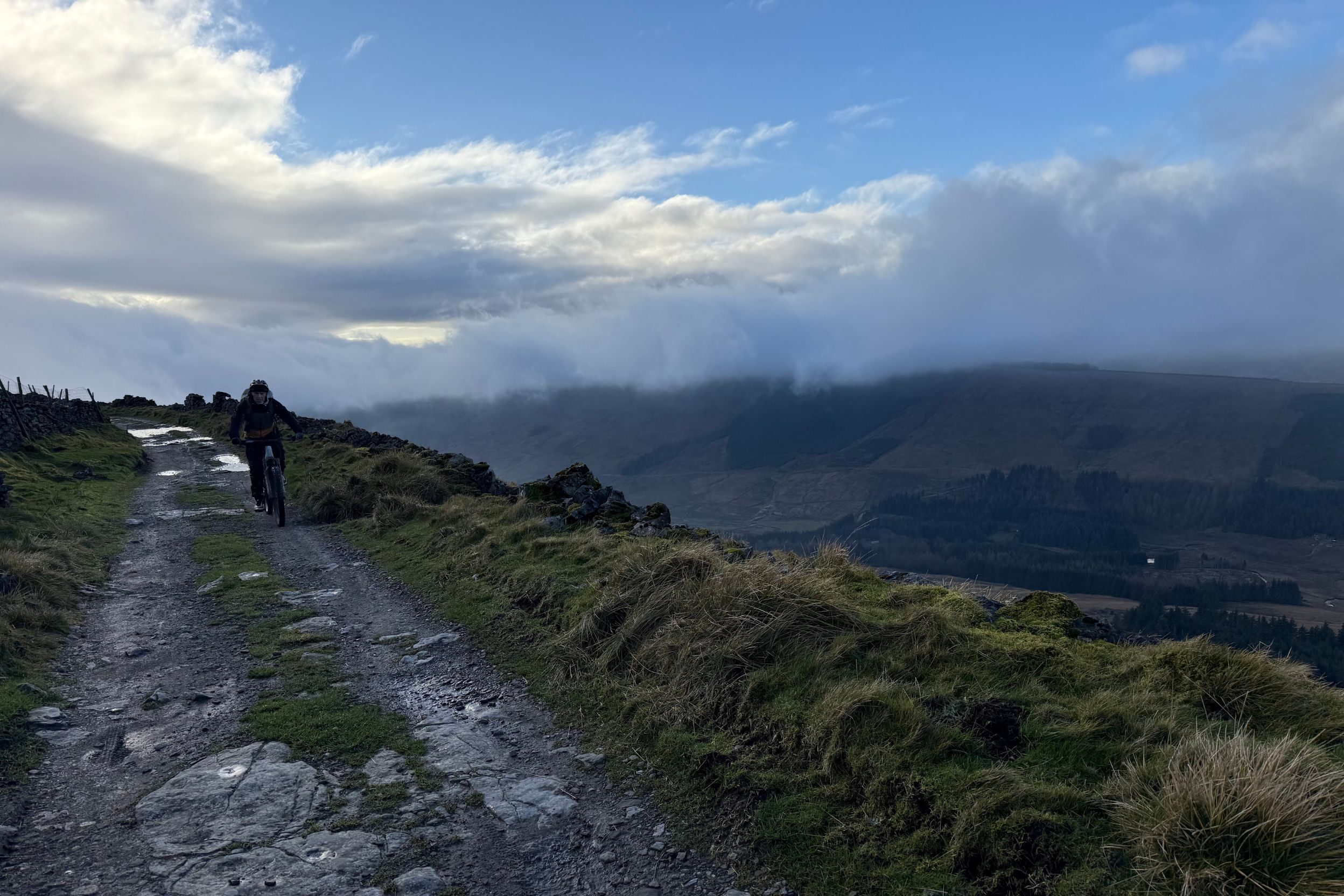
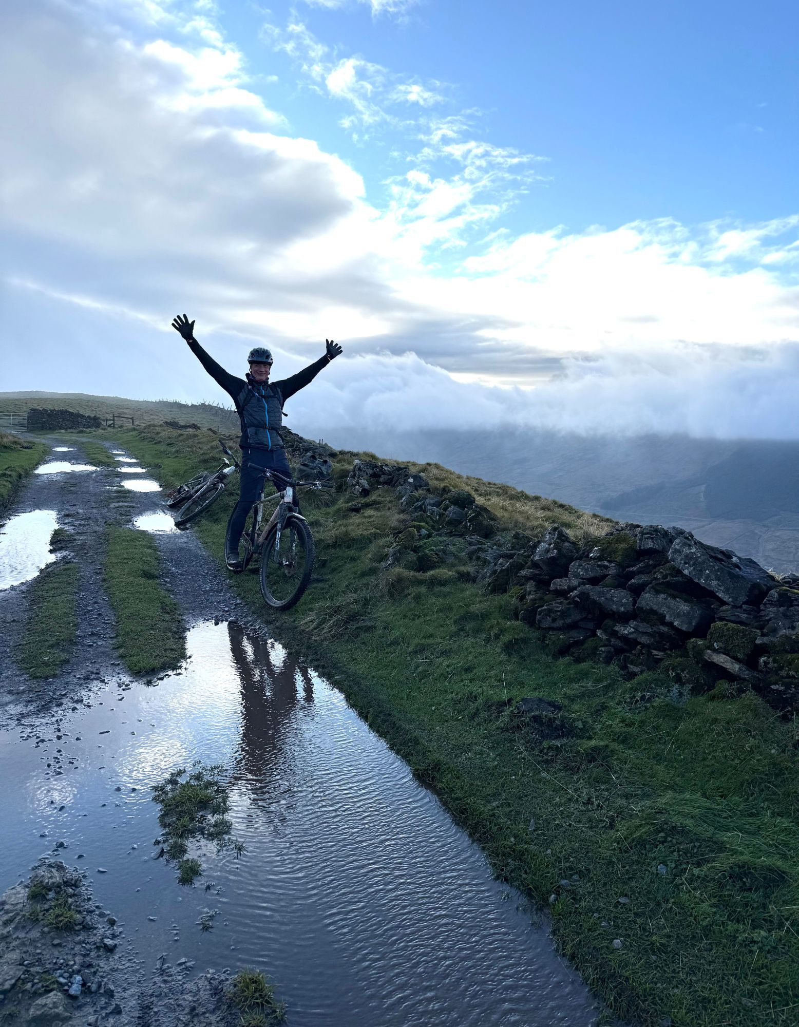
While the original Roman surface is buried a couple of feet deep under the lower sections of Cam High Road, the higher you go, the more the mixed surface is likely to have seen some legionary sandals. Losing yourself in the possible life stories of two millennia of users is a good way to take your mind off the sheer length of the climb too, as while it’s mostly not that steep, 9km of climbing is a lot of tempo to tap out. Alternatively, just take the time to drink in the incredible views over Wensleydale that expand more and more with every pedal stroke.
The top section not only sees the Romans take a slight swerve to sidestep the lump of Wether Fell, but it also puts you onto big sheets of the raw rock that creates the stunning uplands you’re now lumping across. The gentle roll down the far side is a perfect chance to stretch out your legs and back before you go through the gate to join the road at Howgate Head.
Here you’ll be treated to a view straight down the barrel of the infamous final ramp of the road climb up the north side of Fleet Moss. It’s much steeper than the Cam High Road that you just climbed, but significantly shorter and isn’t covered in rocks, so make sure your face looks suitably unimpressed if you see a roadie pain face struggling past.
Howgate Head to Kidhow Gate 17 - 22.2km
There are two options from here, of which we’ve obviously chosen the slightly longer and potentially boggy extra off road choice as the default. If you can’t be arsed with a km of grass, take the right road fork at 17.8km and FFWD straight to the 20.1km.
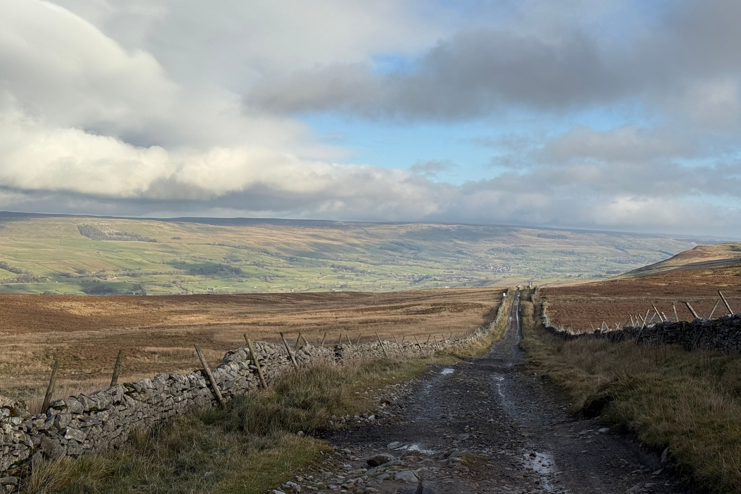
Otherwise, peel left and climb the last two road kickers to the highest point of ‘Long Slack Gate’. On a clear day this gives you views of the peat moorland of Fleet Moss, which is apparently big enough to see from space and is currently being revived by ecologists after disastrous draining and erosion by landowners.
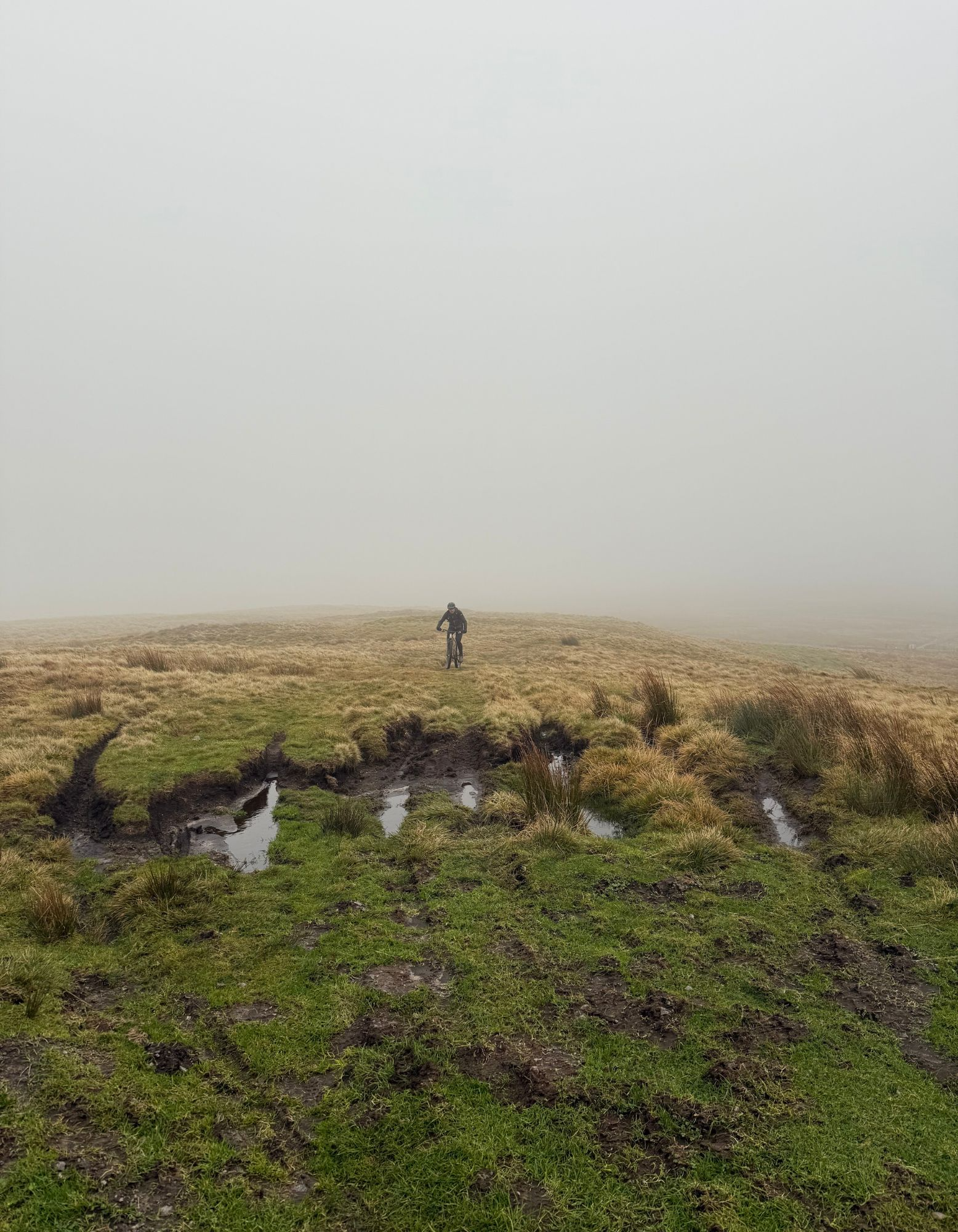
From the summit you curve down on the road for 200m then turn right through a gate onto a double track leading towards a dry stone lined mine entrance from the area’s industrial past. Then it’s a lump and bump along singletrack through a couple of gates to rejoin the spectacularly smooth and well surfaced single track road along the edge of Kidhow. On a good day the views from here out beyond Pen Y Ghent and down Ribblesdale and Langstrothdale are glorious. On a bad day this is where you’ll realise why we told you to pack extra layers as this is a peak weather exposure point. We were certainly glad to turn north out of the sub zero windchill at Kidhow Gate on our recce ride, but if you fancy an extra 20km of surprisingly different riding we’ve added an extra loop south into Oughtershaw in the notes at the end.*
Cam Road 22.2 - 28.9km
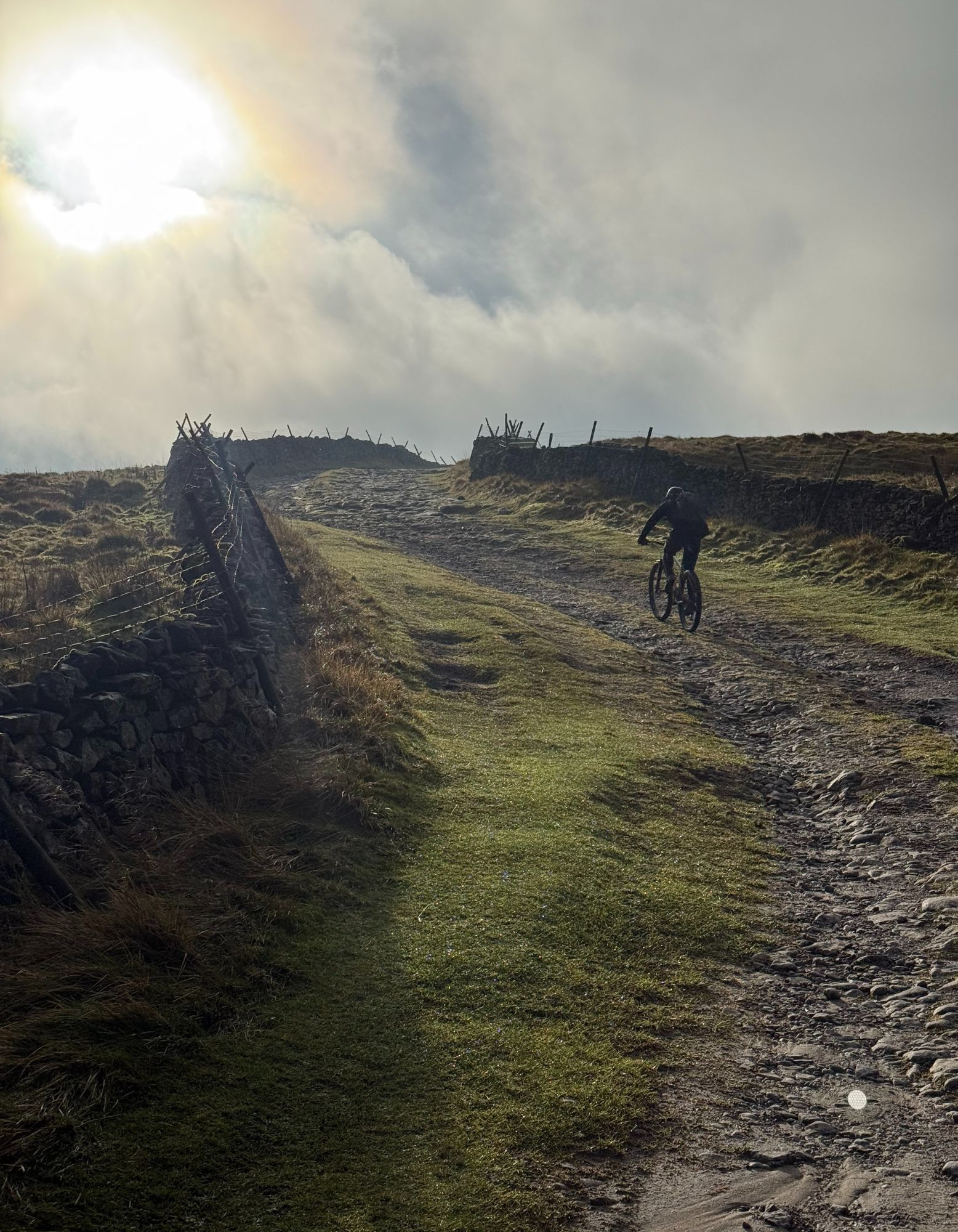
The wildness of this area is reinforced as you head north along the eastern edge of Snaizeholme on the old gravel drove road. While we started in thick cloud, it broke early enough to give an incredible scene of the mist pouring over the steep horseshoe head into the vivid greens and browns of the valley below. The layout of ancient walls, block stone barns and a couple of remote cottages among the cascading streams and huddled woods, likely unchanged for centuries. The rolling hills of Widdale and upper Wensleydale are equally raw and beautiful but don’t get totally transfixed by the view as the top section is shared with the Pennine Way so can be busy with walkers. As the Pennine Way peels off to the right at 26km the track steepens into some loose rocky sections you’ll need to go careful on too. Particularly if you’re on a gravel bike with narrow tyres rather than an MTB. Once the gradient starts to ease off again (around 27km) you can open it up a bit more. Be aware that this is still a popular route with walkers, runners, and horse riders coming up from Hawes so don’t be a dick.
Cam Road foot to Hawes 28.9 - 32km
Don’t overshoot the right turn just before 29km either as you’ll miss out on the final off road descent of Bands Lane and a nice back lane wiggle into Gayle with its historic restored mill and grade II listed stone bridge. The drop into Hawes itself takes you back past the famous Wensleydale Creamery, the fish and chip shop (that also serves fried Wensleydale cheese) and lots of cafes and pubs in the centre of the bustling village, or you could have a burger and soup at Stage 1 like we did. In other words, if you go home hungry you’ve only got yourself to blame.
*Langstrothdale bonus loop
We’ve also got you covered if you’re hungry for more riding when you get to the turn home point at Kidhow Gate (22.2km) on the short loop. This extension into Langstrothdale adds 20km and 320m of descent and climb. That includes some excellent forestry gravel in a remote dale that no-one ever visits and a classic road climb to get you back up to the top.
From Kidhow Gate continue straight on down the Roman Road south west to West Gate (24km). Turn left down the track towards the forest, dropping down to Cam Beck and then climbing again through Cam Woodlands on the fire road, zig zagging down again to 28km. Here you turn back on yourself (heading east) before looping down and westwards to exit the forest onto a tiny back lane (33.4km). This remote ribbon of road rolls downwards through rocky outcrops alongside the waterfalls of Green Field Beck to a T junction at 36km. From here follow the Hawes road north to Oughtershaw where you start the beautiful Alpine style climb up onto Fleet Moss, rejoining the short loop just below the final summit kicker at 40km.